It has been three years since the first node in Europe’s ambitious plan to build a “data highway” in space blasted off from Kazakhstan’s Baikonur Cosmodrome.
European Data Relay System-A (EDRS-A) rode piggyback on an Airbus satellite and now sits in geostationary orbit, 36,000 km from the earth’s surface; a constellation of one.
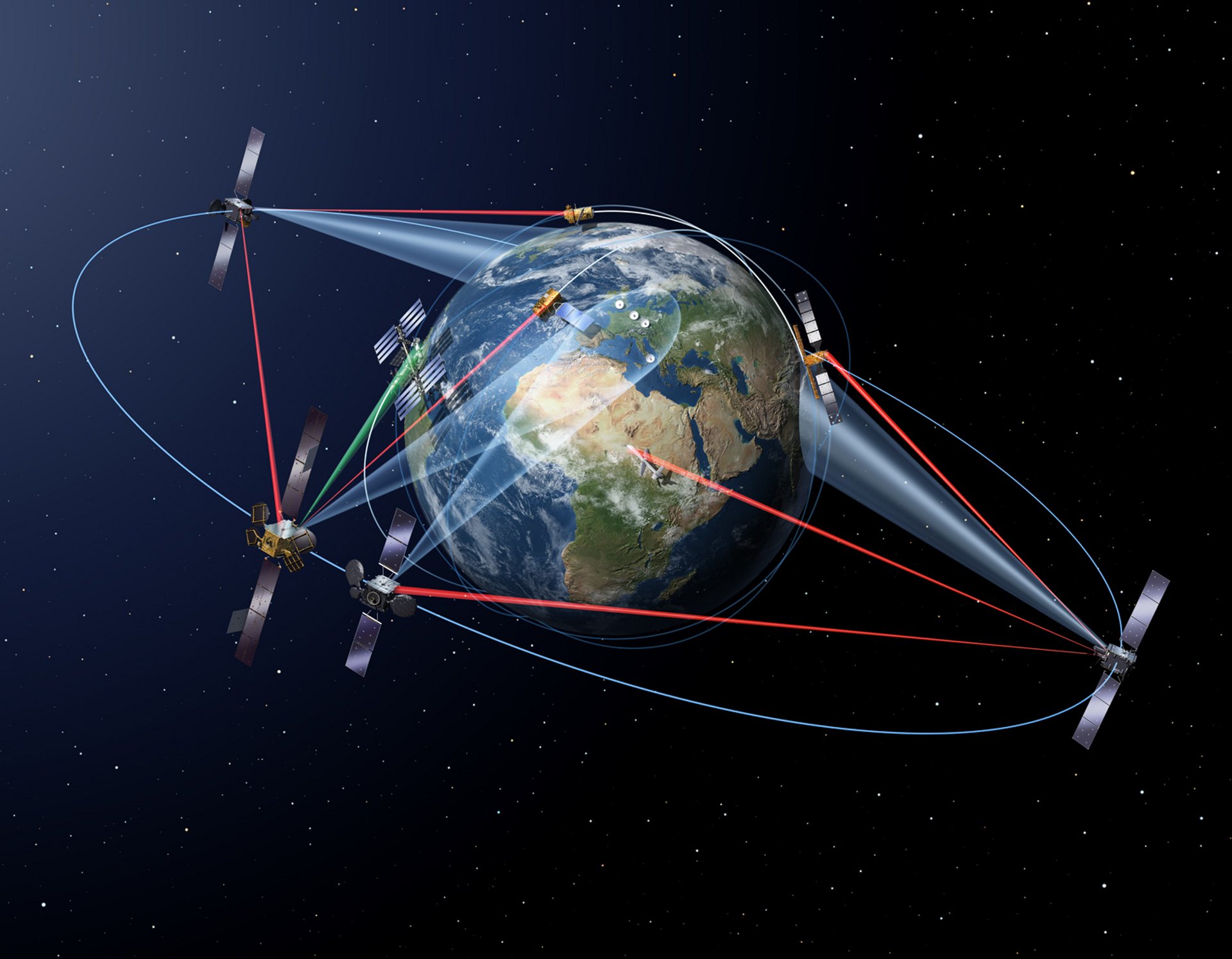
From this vantage point, EDRS-A is able to lock on to low-earth orbit (LEO) satellites below it via laser, harvest their data and relay it at 1.8 Gbit/s to ground stations in Germany and the UK. Its technology means LEO satellites no longer have to store data on board, then wait for “line of sight” with their ground station to transmit data.
In short, it can underpin a much more constant flow of satellite data back to earth, and has already halved the time in which Europe’s Sentinel-2 can provide a full map of the earth’s surface back to a ground station (from 10 days to five days).
The SpaceDataHighway

EDRS-A is part of a public-private partnership between the European Space Agency (ESA) and Airbus, aimed at boosting European independence. The project is known as the European Data Relay System by the former and the SpaceDataHighway by the latter.
Both agree that it is “the most sophisticated laser communication network ever designed”.
And EDRS-A is about to get company.
Airbus and the ESA say that they are approximately five months from a much-delayed launch of the second node, EDRS-C.
As those plans continue, with the second node facing extensive testing, they have also now announced an agreement with Japanese partners to add a third node over the Asia-Pacific region by 2025. This will allow participants to beam data 75,000km across the SpaceDataHighway in near real-time; the world-s fastest “geo-geo” link.

Under the agreement, Japanese telecommunications company SKY Perfect JSAT will work with Airbus on the design of a third satellite expected to be placed in the SpaceDataHighway constellation above the Asia-pacific region by 2025.
The two will co-finance design and development of the satellite payload, dubbed ERDS-D. This will be equipped with the next generation of optic laser communication developed by Telsat, a subsidiary of Airbus.
(These laser terminals will have a superior bandwidth capability than their predecessors and be interoperable with Japanese designed laser terminals.)
With the SpaceDataHighway acting as a relay node for other communication systems in orbit and on the ground, further nodes will boost direct communication links between satellites, ground-bases, ocean fleets, planes and even UAV’s. Full global coverage will make high speed, near-real-time communication possible for all low-orbit satellites.

Satellites placed in low earth orbits of 100 to 2000 km have low latency and can provided high bandwidth communication, they also consume the least energy/cost when launched into position.
However, due to their proximity to the Earth they have a limited field of view of the planet’s surface. In order to receive real-time communications, survey or communications satellites have to work in constellations or a ring of satellites, a costly endeavour. Due to this cost most data collected by low-orbit satellites experiences a delay in transmission.,
Real-time communication is of vital importance for the world’s communication infrastructure, but it can also be a critical priority when it comes to surveying environmental disasters. A satellite above a disaster zone is restricted by what station is close by in order for it to transmit its imagery, delaying the supply of critical information to first responders.
 Laser Communication Terminals
 Laser Communication Terminals
Developed by Telsat Laser Communication Terminals (LCT) are a key piece of technology in the SpaceDataHighway.
(The first laser link between satellites occurred on February 21, 2008 when German and US government satellites established a laser link.)
Telsat LCTs can increase a satellite’s reception capacity up to 50 percent. With their communication infrastructure in place it is possible to re-record all of the Earths landmass, 150 million km², in five days.
The largest of their communication devices the LCT-135 weighs just 53 kg at a size of 60 x 60 x 70 cm, this system has a data rate of 1.8 gigabyte per second and a range of 80,000 km.

Image Source: Telsat
Telsat Laser Communication Terminals use the digital modulation process of binary phase-shift keying to transmit data. Phase-shift keying modulation is widely used in communication technologies today such as Bluetooth and wireless LAN connections. The LCT- 135 uses a 135 mm telescope beam to setup its interconnecting satellite links.
“Due to the extremely narrow filter bandwidth achievable with coherent technology it is also the only modulation scheme that provides full immunity against sunlight, which is not achievable with the optical filters used in direct detection systems,” Telksat state.
See Also: SpaceX Launch Carried 64 Satellites: A Landmark British Payload Among Them