On 4 August 2020, a huge explosion caused by a fire in a warehouse in Beirut’s port devastated the Lebanese capital. The tragedy left more than 200 people dead, 6,500 injured and an estimated 300,000 homeless. The blast also destroyed much of Beirut’s historic areas, including Mar Mikhail, Gemmayzeh and Karantina.
Now, UNESCO and the Directorate General of Antiquities of Lebanon (DGA) are working with French start-up Iconem to create 3D models of the damaged cultural sites to help in their reconstruction. This detailed 3D modelling will not only help Beirut restore its architectural heritage – but will also help the city plan its future.
How Iconem digitises historic locations
Beirut’s port explosion severely damaged 800,000 buildings, including 640 classed as historic. UNESCO immediately initiated an action plan to reconstruct the city’s heritage, and the first task was to create detailed documentation of the affected area. After a call for tenders, UNESCO selected Iconem, which specialises in digitising historical and endangered sites. It had worked with the Paris-based company before on the reconstruction of Aleppo’s old city after it was battered in the Syrian civil war.
Iconem maps its target sites by taking high-resolution photographs, either by drone or by hand, explains Jonathan Chemla, the start-up’s CTO. The images are processed to identify feature points, such as recognisable architectural features, which are then used to stitch the photos together. These are integrated with ‘ground control points’, reference measurements of the topography of the site, to create a detailed and explorable 3D visualisation.
This technique, known as photogrammetry, is significantly cheaper than the industry’s previous approach, which involved laser scanning, as it does not require specialist hardware, Chemla says. Pompeii’s huge 3D digitisation project, which used laser scanning, cost millions of euros. With photogrammetry, expenses could have been brought down to €100,000, he claims.
Iconem’s approach to photographing sites has evolved since its founding in 2013. It used to build its own drones in-house, but commercial equipment now offers longer battery life and higher-resolution sensors. Originally, Iconem’s own staff would take photos on the ground but it has since realised that local workers and researchers are better qualified to navigate these complex and fragile spaces. “So we started teaching archaeologists, researchers and architects how to capture 3D data, how to take the images,” explains Chemla.

Iconem used drones to create a 3D scan of the city in medium resolution. (Photo courtesy of UNESCO)
In 2017, Iconem worked on the digitisation of Angkor, an ancient city in northern Cambodia with iconic temples and sculptures. Chemla and his team taught researchers on site how to take and process images, and how to use the 3D data to understand how the site evolved through time, and where restorations are needed, while Iconem works on the data from its headquarters in Paris.
Mapping Beirut’s heritage after the blast
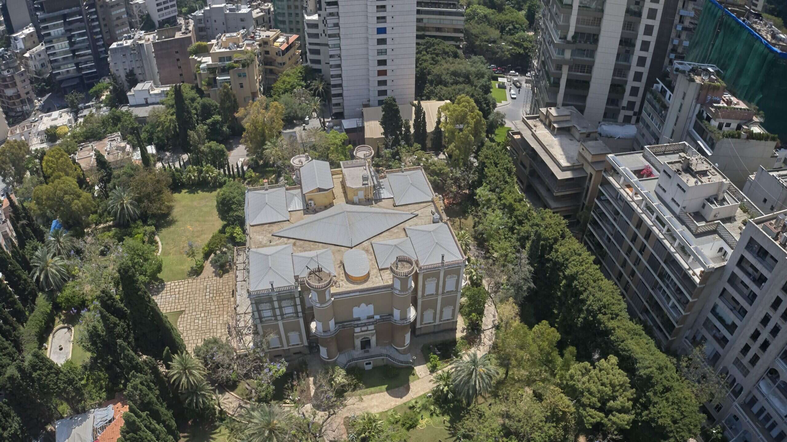
In Beirut, Iconem was tasked with documenting the historic areas affected by the blast and creating a more detailed survey of selected buildings and monuments with a resolution as high as 0.5mm. These included the Sursock Palace, the Ministry of Foreign Affairs, and the Electricité du Liban building – a landmark of the city’s modern architecture.

Sursock Palace, one of Beirut’s landmarks dating from the mid-19th century, was damaged during the August 2020 explosion. (Image courtesy of UNESCO)
“[The project’s objectives] consisted of acquiring field, topographic and architectural data,” explains Joseph Kreidi, programme officer for culture at UNESCO’s regional office in Beirut. “This data will help in the future to get more details about the whole area of Gemmayzeh and Mar Mikhail and having specific details on some historic buildings and landmarks.”
Iconem began work on the project in early December 2020. First, it recorded the ground control points, then took a 3D scan of the city, at between five and ten centimetres spatial resolution, depending on the neighbourhood. Now it is in the process of digitising the selected buildings.
One of the project’s chief challenges is handling vast volumes of data. In its early projects, Iconem would process up to 5,000 photos per site. Now that figure can reach up to 50,000. “It’s a massive amount of data to store, backup and process, so we need to have very powerful computation servers and computers with powerful GPUs and the latest available processors,” explains Chemla. “We use 500GB of RAM. The limitation of the computing power often leads to a limitation in the amount of data you are able to process at a given time.”
Another challenge is integrating images with different resolutions. Photos taken up-close on the ground can reach a resolution of just 1mm, “which is really useful for the interiors, for example,” Chemla explains. But integrating these images with those of larger spaces, photographed at a resolution of five to ten centimetres, can lead to “sub-pixel mismatch”, which can affect the 3D geometry.
As in the case of Angkor, Iconem is transferring the equipment and skills required to document the sites to the local staff, in this case, the DGA. This will not only aid in Beirut’s reconstruction but also its ongoing management says UNESCO’s Kreidi.
“The project is of great benefit to the urban planners as well, so that they will rethink the urban planning of the whole city,” he says. “They can go into details and do a better analysis of the urban areas.”