Occasionally when a new technology begins to break through it hits the headlines for all the wrong reasons. Drones have been in the news more frequently for their misuse, or use for nefarious reasons, than they have been for the potential benefits that they have.
Drones have been used as a way to smuggle drugs into London’s Pentonville prison, sparked concerns over air safety following near misses at UK airports, and has lead to the creation of ‘no drone zones’ around government buildings and at major sporting events.

While issues are clearly yet to be dealt with when it comes to the use of the technology by the general public, several companies and organisations have been looking at ways to use the tech in order to do things such as improve deliveries.
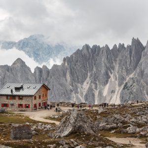
One organisation that is using drone technology is the National Trust, which is responsible for the conservation of historic spaces, areas of natural beauty, and more.
CBR’s James Nunns spoke to Huw Davies, Head of Conservation Information at the National Trust about its use of Esri UKs Drone2Map technology with drones.
JN: What potential use do you see for drones at the National Trust?
HD: “The use of drones is of interest to the National Trust for a number of reasons:
Buildings Conservation: “We’ve been exploring the utilisation of drones for building surveys as some parts of our buildings and structures are difficult to access. In these cases surveys may have previously required the installation of intrusive scaffolding to access the area manually which is both expensive, time consuming and has an impact on visitors. Additionally, in the future we’re starting to think about BIM (Building Information Modelling) and whether we might maintain digital models of our buildings so we can interrogate them to understand things like change in their condition, heat loss or storm damage.
“From a landscape perspective – laser scanning and drone-captured aerial imagery offers an opportunity for our archaeological team to identify potential sites of interest.”
Visitor engagement: “Being able to see the all of the historic buildings, gardens, and landscapes we look after from a different perspective is great for visitor engagement.
“Additionally, we produce a number of publications at the National Trust, as well as maintain a website, so having high res images readily available to publish from angles that readers will not have seen before is a great feature.
“In the future we could use Drone2Map to create 3D models of some of our features, whether that’s our structures, landscapes or buildings, and then present them to visitors to aid interpretation.
“In the future we can even recreate what buildings may have looked like in the past by using virtual or augmented reality with the three dimensional terrain models that we capture from the drone. This can also be presented in a virtual environment for individuals that can’t physically visit our sites.”

Asset management, coastal risk impact vegetation and wildlife stress: “The National Trust looks after 250,000 hectares of countryside. High resolution aerial imagery enables us to easily identify where our bridges, walls, paths, fences and other access infrastructure are, and what condition they are in.
“This data can then be fed into our corporate GIS system and form the basis of a maintenance plan in a timely, efficient and cost effective way. A lot of our gardens have very precise planting schemes, and the high resolution aerial imagery can support the recreation of historical schemes. We can also use these images to look at visitor wear and tear, helping gardeners to plan more sustainable routes.”
JN: Have you come across any challenges using the technology?
HD: “There are various generic challenges around the usage of drones. The safety aspects became apparent and we’re quite cautious with how we approach these. With a substantial amount of visitors accessing our sites regularly, we don’t want to put them at any risk.
“However, we’ve largely addressed these issues with a new policy which requires a full risk assessment, and licensed operators flying the drones. We’ve already started to develop relationships with accredited drone operators.
“The Drone2Map application assists with processing the data and imagery from a workflow perspective, but we still need to consider the machine power required to store and manage this data. There are certainly challenges for us to consider and overcome, however, the benefits seemingly outweigh them, and we are working through these challenges.”
JN: Based on the outputs from the pilot, how might you use the imagery in the future?
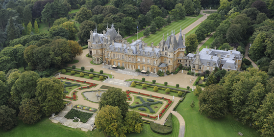
HD: “Drone2Map was used at Cliveden and Waddesdon Manor, both of which are impressive architectural structures. We don’t often have access to views from the angle that the drones are able to provide us with, so it’s definitely beneficial to us and our visitors.
“With regards to building surveys, some of the structures that we look after are quite complicated in terms of the way they’re set out. The high resolution imagery from the pilot can help us to identify any potential vulnerabilities or defects within the building itself.
JN: What interested you about Drone2Map?
HD: “One of the key standouts is the simplicity and shortcutting of previously lengthy processes from data collection and imagery outputs to allow us to make decisions based on the data. Drone2map enhances this workflow as we can easily geo reference information and also eliminate manual inconsistencies that occur when multiple people interrogate the data.
“Drone2map was easy to use in terms of functionality and the fact that it allows us to create whizzy products that create an output for visitors is a fantastic benefit to us.”

JN: How easy is the whole process from data collection to imagery outputs?
HD: “The process is very straightforward, providing you have the storage capacity and processing power to use it. The ease of use is very important for us, especially when there’s an unexpected event in which we need to respond to quickly.
“For example, if there was a storm and we think that one of our structures may have been affected, the quick switch from data collection to imagery output is imperative in assessing if there’s any damage. We need to be able to act quickly as we are dealing with public safety and the preservation of historic buildings.”
JN: Do you expect to be using drone technology more widely moving forward?
HD: “Yes, I think so. It’s still early days, however, we’ve already implemented a policy to address the safety aspects associated with the use of drones and have built relationships with licenced drone operators which is the foundation for using this technology effectively.
“We’re moving forward on an ad hoc basis and are looking at raising awareness with National Trust‘s stakeholders internally to draw attention to the capabilities of this technology. We’re even looking at setting up a conference next year geared towards demonstrating what the technology can do and to really get a clear understanding of where we think we can utilise drones in the future. It’s a tool in the toolkit.”